













The Undercliff Walk puts you between the chalk cliffs and the Channel for about three miles. Start at Brighton Marina, keep the sea on your right and finish at Saltdean. Rottingdean makes a good halfway outing of its own if you’re walking with children or want a shorter trip.
Distance and walking time
| Option | Distance | Walking time |
|---|---|---|
| Brighton Marina to Rottingdean | About 2.3 miles / 3.7 km one way | 50–65 minutes |
| Brighton Marina to Saltdean | About 3 miles / 5 km one way | 60–90 minutes |
Times are planning estimates. Short distances are rounded from the mapped walking line. Allow extra time for stops, conditions and your pace. VisitBrighton’s full-route distance · Independent route description.
Follow the sea wall east
At Brighton Marina, follow the pedestrian signs towards the eastern end and the Undercliff Walk. The route passes below Roedean and Ovingdean before reaching Rottingdean. The village is uphill from the promenade, so factor in the climb if you’re heading up for refreshments or a bus.
From Rottingdean continue along the lower path to Saltdean, then use the access up towards the A259. VisitBrighton puts the full route at about three miles. Allow longer than an hour if you’re stopping or walking into the wind.
How to get there and back
From central Brighton, follow the seafront east to the marina or use the number 7 bus to start at the marina. For the return from Saltdean or Rottingdean, check the Coaster 12 timetable and use the Brighton-bound stop on the main road. If you drive to the marina, read the parking signs and factor in the time needed to return.
Before setting out
The promenade is largely level, but access ramps are sloping and shingle or standing water can make sections difficult. It is shared with cyclists. After rough seas or heavy rain, check the council newsroom for closures and follow signs on the ground. If a section is closed, turn back or use the signed alternative.
Step-by-step directions
- At Brighton Marina, follow the pedestrian signs towards the eastern end and the Undercliff. Join the lower path and head east with the sea on your right.
- Stay on the surfaced sea wall past the Roedean access and Ovingdean. Paths rising towards the cliff top are exits from the lower walk.
- At Rottingdean, take the ramp towards the village for the shorter option. Follow the road up towards the village and check the Coaster timetable for the Brighton-bound stop, or retrace the promenade if you want an out-and-back.
- For Saltdean, continue east on the lower path past Rottingdean. At Saltdean take the access back up towards the A259 and use the Brighton-bound stop for the return.
Parking, toilets and accessibility
Parking
Brighton Marina has visitor parking. Read the signs for time limits before leaving the car, especially if you plan to walk back as well. If starting at the other end, check the Saltdean Lido car park information. Marina parking information.
Toilets
The local route guide lists toilets at the Marina, Ovingdean, Rottingdean and Saltdean. Check seasonal opening and accessible provision before relying on a specific stop. Undercliff facilities guide.
Access and surfaces
The lower promenade is paved and mostly level once you are on it. Access ramps are sloping. Wind, spray, loose shingle and standing water can change conditions, and the path is shared with cyclists. Check closures before setting out and give yourself an exit at Rottingdean if needed.
Route map
The Undercliff Walk
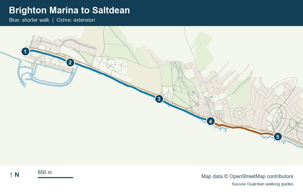
- Marina-side entrance to the lower path
- Roedean access
- Ovingdean café area
- Rottingdean ramp and shorter-route finish
- Saltdean, full-route finish
Undercliff route overview · Undercliff Walk map directory and facilities
For more coastal and countryside routes, see our guide to walks in Sussex.
You May Also Be Interested In